How to Read Property Survey Measurements for Fences
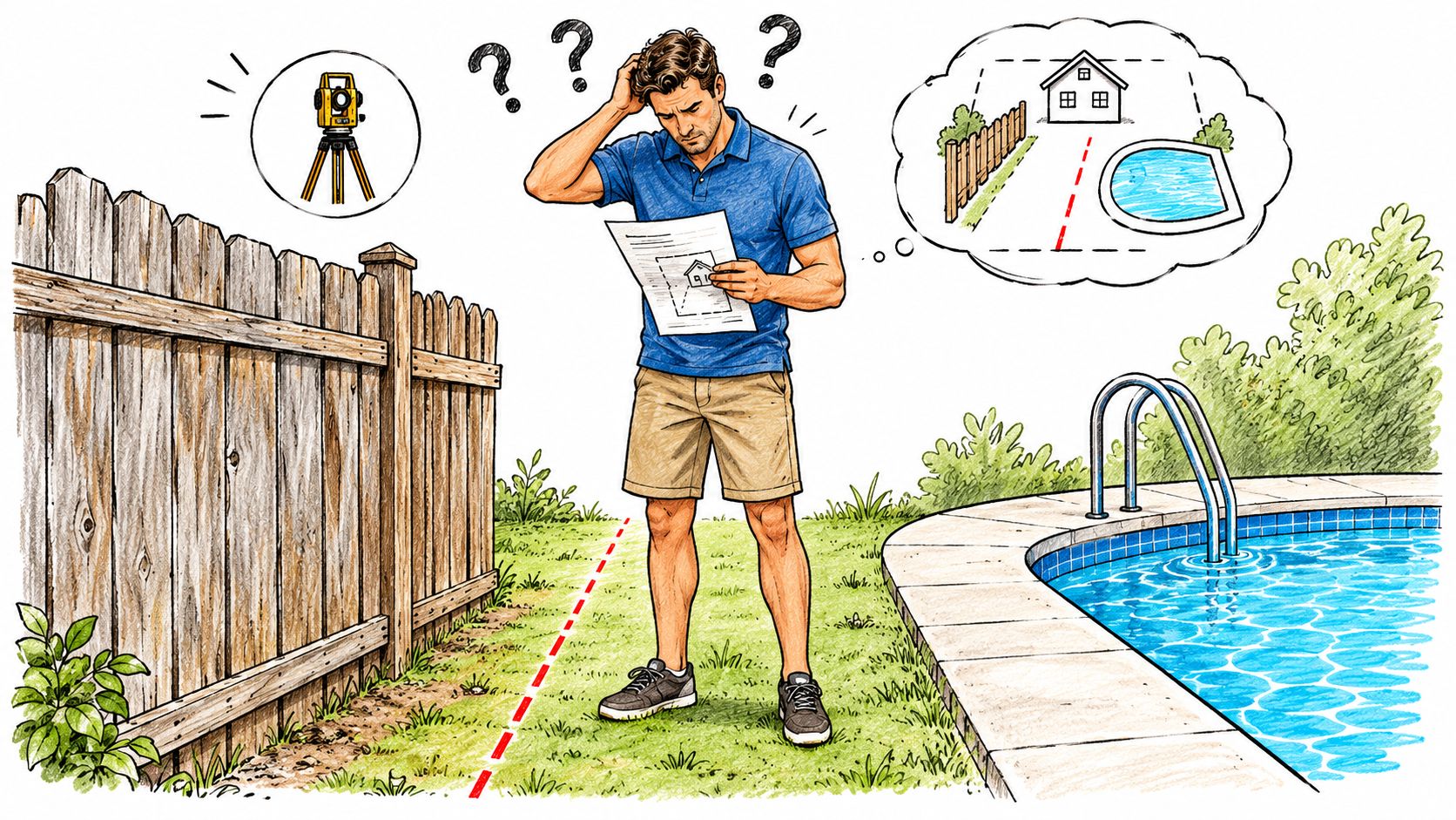
You're standing in the backyard with a printed survey in one hand and a tape measure in the other. The old fence leans a little, the pool deck ends a few paces away, and the bold line on the page doesn't seem to match either one. It's tempting to trust the shortest, clearest gap and start digging post holes there.
That shortcut causes most fence problems. Learning how to read property survey measurements means learning which line is the legal boundary, which line limits where posts can go, and which numbers control when the drawing, a county map, and an old fence disagree.
Table of Contents
- Why Survey Measurements Matter Before Fence Placement
- Read the Survey From Title Block to Boundary
- Decode Bearings Distances and Survey Units
- Trace Each Boundary Course and Check Closure
- Identify Boundaries Easements Setbacks and Rights-of-Way
- Apply Survey Information to Fence and Permit Decisions
- Verify Measurements Before Staking and Construction
Why Survey Measurements Matter Before Fence Placement
A homeowner in Martin County wants a new privacy fence between a pool and a side lot line. On paper, the space looks generous. In the yard, an older fence sits well inside the drawn boundary, landscaping crosses the apparent edge, and a dashed strip runs along the rear. Treating any one of those features as the boundary creates a different fence.
A survey isn't a decorative map. It's a technical record that connects a recorded description to monuments and other evidence found or set in the field. Under the ALTA/NSPS minimum standard detail requirements, a survey boundary is retraced from recorded descriptions, monuments, and controlling references, and an existing fence, GIS line, or tax parcel sketch shouldn't automatically be treated as the legal boundary.
Three Lines That Rarely Match
The legal boundary defines the parcel edge. An installation offset is where posts are placed, sometimes inside that edge to avoid encroachment or preserve access. A permit-required location may shift again because of setbacks, easements, rights-of-way, visibility rules, or pool requirements.
The easiest line to see in the yard is often the least reliable line to build on.
That distinction changes practical decisions. A gate swing that works on the boundary may cross an easement. A panel run measured from an old fence may waste usable yard or, worse, sit on a neighbor's land. Homeowners who are still locating corners should review how to find property lines before installing a fence before marking a proposed alignment.
Reading the whole document matters because no single number stands alone. The title block, survey date, basis of bearings, distances, monument symbols, and closure of the boundary sequence all affect interpretation. Measuring a photocopy with a ruler can't replace those written controls, especially when Florida plat conventions and local approval rules add another layer.
Read the Survey From Title Block to Boundary
Start in the same place every time, and don't follow a boundary line until the reference information is clear. A fast first pass prevents the common error of copying a dimension without knowing its units, date, or direction reference.
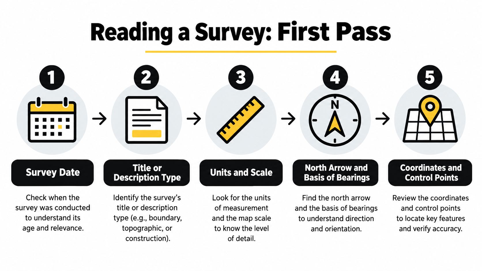
A Repeatable First Pass
- Survey date and type: Confirm whether the sheet is identified as a boundary survey, a plat, or another drawing, and note when field work occurred.
- Title block and certification: Check the property identification, surveyor information, and any notes limiting who may rely on the document.
- Units and scale: Identify whether distances are shown in feet or meters and whether they're labeled record, measured, grid, or ground distances.
- North arrow and basis of bearings: Find the stated reference before interpreting any directional call.
- Coordinate or datum notes: Record them exactly rather than assuming a phone map uses the same system.
- Legend and Point of Beginning: Decode monument symbols first, then locate the documented starting point for the boundary sequence.
Florida law reinforces that order. Under Florida's plat requirements in Chapter 177, plats must identify the bearing or azimuth reference and tie every bearing to a well-established, monumented reference line, so a directional call shouldn't be read apart from the survey's stated reference system. A north arrow alone isn't enough context.
Separate the Drawing From the Controls
After that pass, identify what each graphic element represents. Boundary lines, interior lot lines, offset lines, buildings, driveways, pools, easements, and rights-of-way can look similar on a reduced print. The legend and labels decide, not line weight alone.
Mark a working copy with a pencil. Circle the Point of Beginning, highlight found or set monuments such as iron rods, pipes, or concrete markers, and flag dashed or hatched areas for later review. Don't write over bearings or distances on the only clean copy.
Graphic relationships help with orientation, but they don't override written calls or field evidence. A house may appear centered because the sheet was composed for readability. The dimension tying that house to a boundary is the usable information for fence planning, provided it's read with the correct units and reference basis.
Decode Bearings Distances and Survey Units
Survey notation looks dense because each boundary course packs two instructions into one call. One part gives direction. The other gives length. Reading them separately makes the sequence manageable.
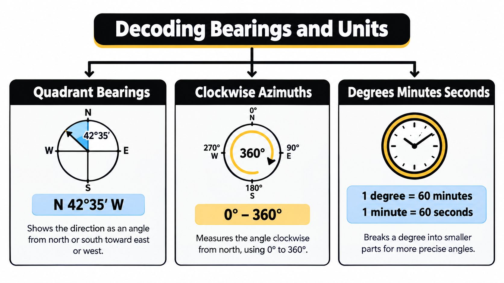
Bearings Are Quadrant Directions
A bearing starts from north or south and turns toward east or west. In the call N 42°35′ W, 120.00 feet, the direction travels 42 degrees, 35 minutes west of north for 120.00 feet, as explained in the metes and bounds reference on bearings and distances. The letters matter as much as the angle because the same angular value falls in a different quadrant when the starting direction changes.
An azimuth works differently. It measures clockwise from north through a full circle, rather than naming a quadrant. Mixing the two systems can send a plotted fence line in the wrong direction even when the distance is copied correctly.
Degrees, minutes, and seconds are subdivisions of angle, not units of length. That's why a small transcription error in the minutes or seconds can rotate a long boundary enough to matter at the far corner. Copy the whole call exactly, including symbols, before asking a contractor to estimate a run.
Decimal Feet and Horizontal Distance
Distances usually appear in decimal feet, not feet and inches. The key conversion is simple once it's stated correctly.
125.50 feet means 125 feet 6 inches, not 125 feet 50 inches.
That same caution applies when a homeowner checks a survey with a tape. Survey dimensions generally express horizontal distance, meaning the length projected onto a horizontal plane. A tape pulled over sloping or uneven ground follows the surface and can read longer than the stated boundary distance.
Units and dates also affect older records. Legacy documents may use different foot definitions, older units, or coordinate notes that don't match a modern digital file. Rounding adds another small difference when plat dimensions are compared with field measurements.
Don't resolve those differences by scaling the printed sheet with a ruler. Paper prints, PDFs, and screenshots can be resized. The written bearing, distance, units, datum notes, and basis of bearings control the technical interpretation. When those items conflict, the surveyor who prepared or retraced the boundary is the right person to explain which value governs.
Trace Each Boundary Course and Check Closure
A metes and bounds description reads like walking directions for the parcel perimeter. Metes are the measured courses. Bounds are controlling physical or legal features such as roads, streams, monuments, or adjoining parcels. The description works only when the courses are followed in the stated order.
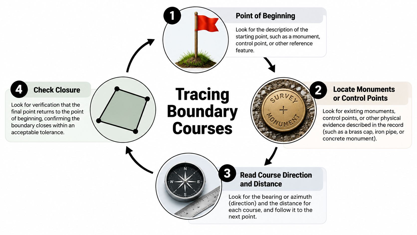
Begin at the documented Point of Beginning. Identify the monument or control point referenced there, then read the first bearing or azimuth and apply its distance to reach the next corner. Continue course by course around the parcel, noting each monument, adjoining parcel, road, or other controlling feature named in the description.
What Closure Tells the Reader
A complete sequence should return to the starting point. That return is called closure. Plotting every course on paper or in simple drafting software gives homeowners a useful quality check before a fence estimate, even though it doesn't certify the boundary.
If the final point lands somewhere else, don't nudge the line until it fits. An open or inconsistent closure may indicate a transcription error, conflicting record data, or a need for professional interpretation. Record calls can also conflict with physical occupation, such as a fence, hedge, or driveway that has sat off the boundary for years.
Older descriptions require extra care because they may use rods or poles instead of feet. Convert those legacy units consistently before plotting, and ask the surveyor to confirm the conversion if the record is faint or abbreviated. Mixing one converted course with unconverted field measurements creates a false closure problem.
A Fence Example Where Shifting Is Wrong
Suppose a rear course plots several feet beyond an existing chain link fence. Moving the proposed vinyl fence to the old posts feels safe, but it may surrender usable yard and still miss a required pool or access dimension. The opposite error is worse. Extending posts to the plotted line without field verification can create an encroachment if a monument, title call, or adjoining boundary controls differently.
The correct response is to stop layout and document the conflict. Note the course, the monument notation, and the feature that disagrees. A licensed surveyor can retrace the evidence and determine the boundary. A fence contractor can then price the confirmed alignment instead of guessing between two plausible lines.
Identify Boundaries Easements Setbacks and Rights-of-Way
Most placement mistakes come from treating every line near the parcel edge as the same kind of line. They aren't. Each feature answers a different planning question.
Survey Line and Fence Placement Guide
| Survey Feature | What It Represents | Why It Matters for Fences |
|---|---|---|
| Legal boundary | The parcel limit described and retraced from record evidence and monuments | Defines the outer limit. Posts placed beyond it can encroach. |
| Required setback | A local code or zoning separation from a boundary or feature | Can push the fence inward even when land remains beyond the setback line. |
| Easement | Land subject to another party's stated use or access rights | May restrict posts, gates, footings, landscaping, pools, or structures within the area. |
| Right-of-way | Land reserved for a road, utility, or public access purpose shown on the record | A fence inside the parcel can still conflict with access or visibility requirements. |
| Offset installation line | The proposed fence alignment measured from the boundary or another control | Converts legal information into a buildable line with room for posts and construction tolerance. |
| Structure or pool dimension | A measured tie from a boundary to a fixed improvement | Helps test gate location, pool enclosure fit, and remaining usable space. |
An easement isn't automatically the property edge. It's a restriction or right affecting part of the property. A homeowner may own the land under a utility or drainage easement and still be unable to place permanent footings, a gate operator, or dense landscaping there without approval.
Florida's standards explain why improvement dimensions deserve attention. The Florida boundary survey standards in Rule 5J-17.052 require the surveyor to locate relevant monuments and evidence of occupation, show discrepancies between the map and legal description, and depict relevant fixed improvements directly or through offset lines. Those offsets help translate a house, driveway, or pool location into fence decisions.
Before choosing an alignment, list every constraint touching the run. Check the boundary, each easement, any right-of-way, required setbacks, gate access, and dimensions to structures. Guidance on how close a fence can be built to a property line should then be checked against the specific city, county, and HOA rules for the parcel.
A fence can sit entirely on the owner's land and still be in the wrong place.
Apply Survey Information to Fence and Permit Decisions
A privacy fence in Palm Beach County may look straightforward until the survey is marked up. The rear boundary is clear, but a drainage easement crosses one corner and a side gate must preserve access to equipment. The buildable alignment follows the confirmed boundary or approved offset only after those constraints are drawn.
Start with a working copy, not the signed original. Shade easements and rights-of-way, mark required offsets, and write questions beside any dimension that doesn't match field conditions. That marked copy gives a fence estimator, permit reviewer, and surveyor the same reference points.
Privacy Fences, Pools, and Gates
For a privacy fence, survey ties to the house and driveway determine where panels terminate and where a gate can swing without crossing a restricted area. For a pool enclosure, the surveyed pool, deck, doors, and boundary relationships matter more than a guessed rectangle paced off in the yard. Gates need special attention because posts, hinges, latches, and operators occupy space beyond the centerline drawn for the fence.
Allied Fence and Gate's survey and photo upload process is one practical example of how project records are used before estimating. Uploaded surveys and site photos can support measurement review, while utility locates, permitting support, and inspection coordination remain separate field and approval steps. A digital extraction doesn't replace a licensed surveyor's boundary determination.
Sloped Lots and Permit Drawings
Slope creates a quieter error. Florida subdivision plat dimensions refer to a horizontal plane, and 75.25 feet represents horizontal distance rather than a slope measurement taken over uneven ground, according to Florida Statute 177.091 on plat dimensions. A tape laid down a swale or bank can therefore disagree with the survey without either measurement being careless.
Permit drawings should show the proposed fence against those surveyed controls, not against a screenshot from a parcel map. Homeowners preparing documents can use the fence permit application guidance to organize the survey copy, proposed alignment, gate locations, and flagged easements before submission. If a dimension can't be reconciled, leave it flagged. Reviewers and contractors solve a noted conflict faster than a hidden assumption.
Verify Measurements Before Staking and Construction
Verification is a short routine, done before stakes go into the ground. It catches mismatched units, copied bearings, and proposed posts that drift into restricted areas.
- Document check: Confirm the survey date, units, scale, basis of bearings, datum notes, and whether distances are record, measured, grid, or ground.
- Closure check: Plot or calculate each course in order and confirm the sequence returns to the Point of Beginning.
- Constraint check: Compare the proposed fence with every easement, right-of-way, setback, access point, structure, and pool dimension.
- Evidence check: List any conflict among monuments, occupation features, GIS mapping, and the written description instead of averaging them.
Beginning January 1, 2023, new U.S. surveying and mapping data expressed in feet use the international foot, while historic records may retain the older U.S. survey foot, and legacy and modern units should not be mixed, according to NOAA guidance on retiring the U.S. survey foot.
Contact the surveyor when monuments can't be found, the description doesn't close, or old and new records disagree. Contact the permitting authority when setback, easement, or pool placement rules are unclear. Give the fence contractor the marked working copy and the written answers, so layout follows resolved controls rather than verbal assumptions.
A survey helps a homeowner understand the site. The correct fence line comes from applying its measurements together with property evidence, access needs, and local approval rules.
#MartinCountyFencing #PalmBeachCountyFencing #StuartFencing #JupiterFencing #PalmBeachGardensFencing #PortStLucieFencing #TreasureCoastFencing #FloridaFence #VinylFenceFlorida #AluminumPoolFence #PrivacyFence #PoolSafetyFence #FencePermit #PropertySurvey #BoundaryFence
If a survey dimension, easement, or setback is holding up a fence plan in Martin County or Palm Beach County, AlliedFenceAndGate.com™ can review the uploaded survey and site photos, help translate the confirmed alignment into an estimate, and coordinate permitting, utility locates, and inspections. Visit the site to start with the project documents already on hand and turn those measurements into a buildable fence layout.
Related Fencing Services
Need a fence or gate on the Treasure Coast?
Licensed, insured, and bonded. Free estimates across Martin, St. Lucie, Indian River & Palm Beach counties.
Call (772) 530-3127